Hello everyone!
Thank you so much for supporting the development of the mapping tool with your feedback, bug reports, and suggestions!
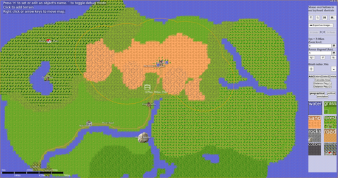
Version 0.6.2 of the mapping tool is out, with several important improvements including unlimited scale and image exporting. This is the last version of the mapping tool to be developed as an MVNU project, as I have graduated! In the future, the mapping tool will be developed as an open source project.
You can download it here: https://github.com/mapper1024/mapper1024/blob/master/DOWNLOAD.md#download-options
You can use the online demo here: https://mapper1024.github.io/demo
Image Exporting
You can now save parts of the map as images to be used as illustrations for a book, for a website, or for whatever you want.
Unlimited Scale
The scale of your maps is now unlimited, with a few handy controls to set exactly what scale you want to edit your map at at any given moment: you can edit on the scale of meters to design a city, or on the scale of hundreds of kilometers to design a continent. Whatever you like, all in the same map.
What’s Next
Just because I graduated doesn’t mean that the mapping tool is done. I’m going to keep working on it! Features like altitude controls, better performance, alternate graphical styles, and more are all in the pipeline. I’ll also be releasing the tool as an open source project so that anyone interested can contribute ideas, code, and art.
Stay in Touch
Feel free to e-mail me at ben@benleskey.com for anything! You can also post feature requests or bug reports using the mapping tool issue tracker.
If you’d like to keep up with development of the mapping tool and try out new releases, all mapping tool news is posted on my website. An rss feed for news is available, as well as an atom feed for releases.
Thank you again for your support, and I hope you continue to enjoy the mapping tool as it grows and evolves!
